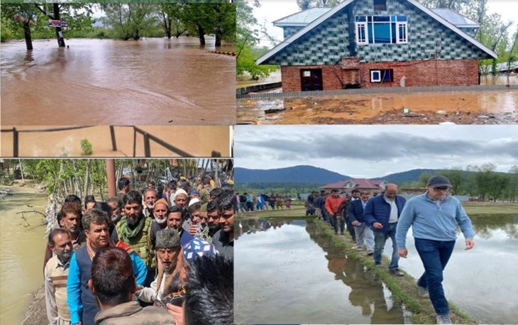
Srinagar: As the flood threat waned with the decrease in the water level of the Jhelum River, concerns have arisen over the lackadaisical implementation of the much-publicized “Flood Control Project” by the central government, which was announced after the devastating floods of 2014.
 With an improvement in weather conditions this week, the water began receding from the Jhelum River and other streams across Kashmir, alleviating the flood threat. The Jhelum River, originating from south Kashmir’s Verinag, which had surpassed the flood declaration point, is now flowing below the flood alert level, with water receding steadily. The Meteorological Office has forecasted mainly dry weather for the next four days. Following the crossing of the declaration point by the Jhelum and other streams, the government established Flood Control rooms in every district. At least 336 families from the flood-affected areas of Kupwara district were relocated to safer places by the District Administration in Kupwara. Around 51 villages of the district have been partly affected, while 5 villages of Handwara area were affected by the floods. The floods damaged some major infrastructure in the district including Shumriyal Bridge, Khumryal Bridge, Shatmuqam Bridge, Sohipora- Hayhama bridge, Farkyan bridge, two RDD buildings at Kupwara and AD Handicrafts office building. Shumryal- Gundajhanger road got cut-off due to scouring and a breach in Doban Kachama dam. Authorities also suspend classes in affected areas, impacting 34 schools district-wide, including 14 within the Handwara education zone.
Aziz Ahmad, Additional Deputy Commissioner of Handwara, clarified that this measure was precautionary in response to the floods. While most affected buildings are deemed safe, thorough inspections will precede their reopening. Efforts to dewater and clean submerged schools are underway, with the majority now cleared for class resumption.
“Full restoration is expected to take up to a week, with temporary accommodations arranged in nearby schools. Despite lingering water in some schools, assessments post-dewatering will determine further remediation needs. Structural concerns may delay the reopening of some schools, prioritizing student safety,” he said. The fear of floods in Srinagar, especially after the 2014 deluge, remains prevalent among residents. Ali Mohammad said they have witnessed the devastation caused by floods in Srinagar and other parts of Kashmir. Whenever there is continuous rainfall, people living close to the Jhelum River and other streams start to panic. This time, too, when the rivers, especially the Jhelum, began to swell, people started worrying, he said. “Now, the danger has diminished. We are concerned regarding incomplete government works necessary to prevent future floods, particularly increasing the carrying capacity of the Jhelum River as it passes through Srinagar,” Ali said. April witnessed extensive rainfall in Kashmir, making it one of the wettest months in contemporary history. With rains persisting for about 20 days in the Kashmir valley and significant snowfall in higher reaches, concerns of flooding heightened, reminiscent of the 2014 deluge.
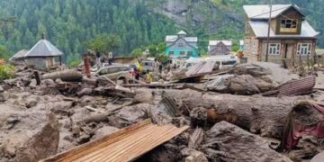
Inquiring minds across Srinagar are questioning the government’s efforts to prevent a repeat of the 2014 catastrophe. Some voices express anger, while others whisper in concern, but the sentiment is unanimous – the need for action is urgent. In Ramban district, approximately 60 houses in Parnote village on the Ramban-Gool Road were damaged due to land sinking, compelling 500 residents to evacuate. Additionally, numerous houses were partially damaged, painting a grim picture of the area’s plight. North Kashmir faces similar challenges, with thousands of apple trees uprooted, villages flooded, and educational institutions shuttered due to inundation. The World Bank provided substantial funding to J&K for flood mitigation post-2014. However, a comprehensive action plan to address future flood threats remains elusive. The government must prioritize flood control measures and provide regular progress updates to instill confidence in the populace. Floods pose a significant threat to Kashmir’s agrarian economy. Only through meticulous planning and diligent implementation can Srinagar develop a robust contingency plan to mitigate the risk of flooding from the Jhelum River’s rising waters.
Kashmir Horizon View: The team Kashmir Horizon after visiting certain flood hit areas noted the following priorities in the light of public responses for attention and intervention of the Government in future:-
- Prioritize the completion of the Flood Control Project, ensuring all necessary works, such as increasing the carrying capacity of the Jhelum River, are swiftly executed.
- Address bureaucratic hurdles and expedite the tendering process for essential projects to prevent delays and ensure timely execution.
- Establish mechanisms for regular monitoring and reporting of project progress. Transparency in fund allocation and utilization will build trust and accountability.
- Conduct awareness campaigns to educate residents about flood risks, evacuation procedures, and precautionary measures to minimize damage and casualties.
- Develop and strengthen infrastructure resilience measures such as embankments, floodwalls, and drainage systems to mitigate the impact of future floods.
- Utilize modern technology such as satellite imagery, early warning systems, and GIS mapping to enhance flood forecasting, monitoring, and response capabilities.
- Seek expertise and support from international organizations and agencies with experience in flood management to implement best practices and innovative solutions.
- Preserve and restore natural floodplains, wetlands, and forests, which act as natural buffers against flooding and contribute to ecosystem health.
- Community Engagement in Decision-Making: Involve local communities in decision-making processes related to flood management, ensuring their concerns and perspectives are considered in planning and implementation.
- Develop comprehensive, long-term strategies for flood risk reduction and climate change adaptation, taking into account projected changes in rainfall patterns and river dynamics.


